
Communities on alert as cyclone edges closer
By ROBYN WUTH
Evacuation centres have opened with communities in remote regions of Western Australia ordered to take shelter as a tropical cyclone inches closer.
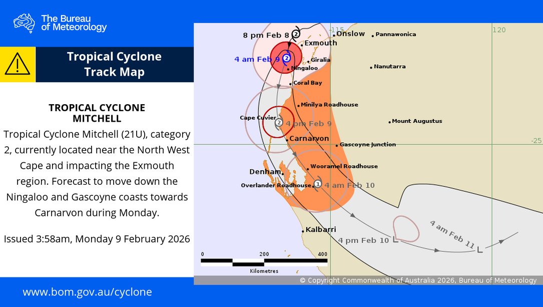
WA’s North West Cape is bracing for Tropical Cyclone Mitchell which has been downgraded to a category two system but is still packing winds of up to 130km/h.
Widespread power outages have been reported as the system tracks along WA’s coast with forecasters predicting it to make landfall on Monday night.
Cyclone Mitchell was 110 km southwest of Exmouth and 240km north of Carnarvon on Monday morning, the Bureau of Meteorology said.
A cyclone emergency has been issued for the area south of Onslow to south of North West Coastal Highway to north of Coral Bay, including Exmouth and Ningaloo.
“There is a threat to lives and homes. You are in danger and need to act immediately,” authorities warned.
“Shelter indoors now. It is too late to leave. Stay in the strongest, safest part of the building. Stay away from doors and windows, and keep them closed.”
Cyclone Mitchell is expected to weaken by Tuesday morning as it moves over land through the southern Gascoyne.
Torrential rain
The cyclone was rated a severe category three system before weakening.
Torrential rain, and winds gusts up to 120km/h have been reported along the coast east of Giralia to Coral Bay.
They are expected to reach Cape Cuvier and inland parts of the western Pilbara and far northern Gascoyne on Monday.
Residents are bracing for flash flooding, and abnormally high tides along the Pilbara coast and Gascoyne region.
“We have seen a reasonable amount of rainfall – it’s been the wind that has been most powerful and most impressive so far, particularly again, over those offshore islands,” senior meteorologist Angus Hines said.
A watch and act was issued from Onslow south to Coral Bay, including Exmouth and Ningaloo. (Aaron Bunch/AAP PHOTOS)
“We expect to see heavy rainfall and storms could lead to flash flooding, could lead to rivers flooding, and will almost certainly lead to significant road closures, which may isolate communities.”
Strong wind gusts could bring down trees, damage property and cause significant power outages.
“This weather system is going to be with us for a number of days as it’s going to slide southwards through the interior of Western Australia as a weakening, decaying weather system between Monday and Wednesday,” Mr Hines said.
AAP