
New radar to improve weather forecasting in remote regions
A new weather radar in the Barkly region is one step closer, with the Bureau of Meteorology now in the final stages of negotiations with Airport Development Group for the radar to be installed at Tennant Creek Airport.
It’s anticipated the radar will be located at the Bureau of Meteorology’s existing airport site. Final stages of site-specific design work are now underway.
The new radar is jointly funded by the Australian and Northern Territory Governments as part of the Barkly Regional Deal.
Coverage will include Tennant Creek, Elliott and smaller townships and First Nations communities.
“Securing a site brings us closer to delivering this vital radar which will help community, industry and emergency management make more informed decisions in the Barkly region,” Federal Minister for the Environment and Water, Murray Watt said.
Observe rainfall and wind conditions
The new weather radar will be a high-power S-band dual-polarised Doppler radar. It will have enhanced performance and range compared to the original Tennant Creek radar, and will help to observe rainfall and wind conditions in real-time across large areas.
The new radar is expected to be operational by mid-2027 once construction and testing is complete.
The airport site was selected due to several advantages, such as an existing Bureau lease, connection to 3-phase mains power, and a building suitable to house the radar equipment.
Bureau of Meteorology CEO Dr Stuart Minchin thanked the community and Barkly partners for their patience and positive engagement.
“With the site now confirmed, our focus will turn to the complex process of installing and calibrating this highly sophisticated piece of infrastructure,” he said.
The radar for this site has already been constructed and is ready to be shipped and installed once the foundations have been poured.
During the construction of the new radar, the community can continue to access Barkly region and Northern Territory weather information from a range of BoM sources.
“Finalising a site for the new weather radar is very welcome news for Tennant Creek and the Barkly region,” Minister for Indigenous Australians and Senator for the Northern Territory, Malarndirri McCarthy, said.
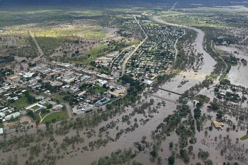
Radar information will assist communities and the NT government manage the wet season and the flood concerns.
“As our most recent wet season highlighted, radar information is crucial for Territory communities facing floods, including First Nations communities.”
Radars are just one part of a composite observing network, which also includes satellites, lightning detection and upper air and surface observations. Australia has one of the world’s most extensive observation networks – more than 11,000 assets – including satellites, upper atmosphere monitoring, automatic weather stations, ocean buoys and flood warning networks. This is used to deliver data for forecasts, climate outlooks and other vital services.
For more information on the network, visit: www.bom.gov.au/resources/observation-network